
These open-source tools leverage machine learning and crowdsourced data for urban development in Latin America and the Caribbean
“We don’t have data on that.” We hear these words repeatedly while working on urban development projects with cities and countries in Latin America and the Caribbean. This is problematic when we consider the region’s population is already 80% urban. Considering the digital revolution, Latin American and Caribbean cities should be poised to generate, analyze, and disseminate urban data. Yet, all too often, our partners do not have the tools necessary for delivering urban services to informal areas, identifying and allocating lands best suited for development while protecting at-risk areas, and working with individual families to assess and improve housing conditions, among other tasks. Much of the existing technology available to support this work is either too expensive, difficult to use, or not designed for the specific conditions of cities in a developing country.
Open-source tools for Urban Planning in Latin America and the Caribbean
To address these needs, the IDB’s Housing and Urban Development Division (HUD) has developed an Open Urban Planning Toolbox, a set of open-source tools to support each step of the urban development planning process, from early design through implementation and evaluation of projects.
The methods and functions of the tools are mixed; Some use techniques such as machine learning as well as crowdsourced data. Finally, considering the importance of “ground-truthing” or field verification of the data and the understanding of urban challenges at the neighborhood and home level, we have also adapted a digital system of data collection in the field to guarantee information faster and spatially accurate.
All tools included in the toolbox to date are listed below. When a new tool is added, the list will be updated here. The links take you to the sections that describe each tool in more detail:
- Building Detection Model
- Urban Growth Model
- OSM Extraction Tool
- OpenMapKit
- Housing Deficit Estimator
- Georeferenced Program Evaluation (GPE)
- UrbanPy
These tools were developed by leveraging academic and private sector expertise in the context of specific IDB-funded projects. These include projects in Guyana, with the Adequate Housing and Urban Accessibility Program (GY-L1031) and Sustainable Housing for the Hinterland (GY-L1028); and Buenos Aires, Argentina (RG-T3397) within the framework of the Cities Laboratory. Several of these projects have included training and testing sessions between public officials and beneficiary communities to strengthen the development and use of the tools. By sharing the tools through the IDB’s Code for Development initiative, we invite our fellow planners and technologists to use and improve on the Open Urban Planning Toolbox.
1. Identify existing structures with the Building Detection Model
City planners often lack updated digital maps of existing buildings and structures. The Building Detection Model can automatically generate a basic map of buildings from satellite images. It uses semantic segmentation, which is the process of assigning each pixel in an image into a category; in this case, the categories are ‘building’ or ‘not building’. This allows planners to create detailed digital files of hard-to-reach and remote areas, such as the Guyana hinterland, where our partners are currently planning for housing interventions.
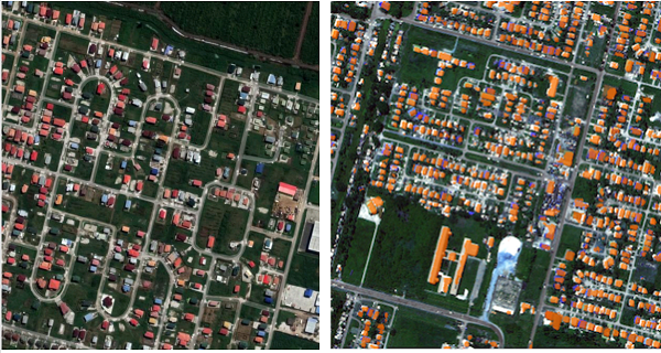
Beyond generating a map of existing structures, urban and housing agencies can use the model’s results to estimate population size, neighborhood density, access to resources, etc., and as a base across which to extrapolate household level information. In addition, these estimates can help with downstream tasks such as measuring and detecting unplanned/informal urban sprawl, informing planned interventions and the provision of urban ecosystem services to such areas.
The model, which uses machine learning techniques for the basic categorization, was trained on data from Paramaribo (Suriname), Georgetown (Guyana) and Belize City (Belize), all of which have similar climate/vegetation, styles of architecture and patterns of urban sprawl. For improved results, the model should be re-trained for a new city with different topography and sprawl patterns.
Inputs: Satellite images
Method: Semantic segmentation with Raster Vision
Language: Python
Outputs: Building footprints
2. Project growth with the Urban Growth Model
While urban growth prediction models are not new, they have historically required significant resources in time, expertise, and calculations. This model automates that process, allowing urban planners to spatially extrapolate the growth of their city under different scenarios (e.g., future population size, different time horizons, sensitivity to restricted areas, degree of randomness, etc.), based on past growth and current land use.
As inputs, the model uses monochrome images with standardized size and boundaries prepared from satellite images of an urban area. These images can be physical maps, density maps, or maps denoting legislative or social boundaries, depending on the conditions of the urban area and the modeler’s discretion. Attraction features will include, for instance, proximity to transit stations, and will be assigned a positive weight; restrictor features will include conditions such as flood-risk or conservation lands and will be assigned a negative weight.
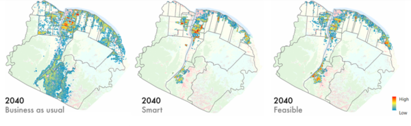
Using these inputs, a regularized spatial logistic regression model predicts future urban growth on a pixel-by-pixel level within the determined boundaries, and outputs a binary raster file showing growth.
Inputs: Processed single-feature images
Method: Lasso-regularized spatial logistic regression
Language: Python
Outputs: Binary prediction file
3. Generate neighborhood-level maps with the OSM Extraction Tool
Even in relatively well-established urban areas, development can take place informally or without complete records. Luckily, OpenStreetMap (OSM) uses crowdsourcing to generate detailed data at the building level. It is not always easy to download this data, however. Previously, an API called Overpass has been used to pull this data, but it requires knowledge of its own specific query language, which can be a significant barrier to urban planners without training in programming.
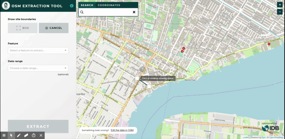
Our OSM Extraction Tool eliminates the need to write any code and offers a more user-friendly and intuitive interface to extract relevant shapefiles and fill data gaps. The tool allows users to select specific areas; download detailed maps of roads, buildings, and other features in those areas; and update or add information to existing GIS data. Files downloaded from the OSM Extraction Tool can be conflated (selectively merged) with existing records using JOSM (Java OpenStreetMap) editor.
Inputs: Existing GIS data (if none is available, this tool can still work with no base data)
Language: JavaScript
Outputs: Shapefiles (roads, buildings, waterways, etc.)
4. Empower digital field data collection with OpenMapKit
Paper records are still quite common for field data collection in many housing agencies, where the infrastructure required to create, implement, manage and maintain survey data often includes paywalls or high levels of technical expertise. OpenMapKit (OMK) solves one of the most immediate needs for government agencies to collect and manage data from the field, incorporating automatic georeferencing into the collection process.

The kit consists of an Android mobile device and three software components: the OMK Server (which allows users to store and manage survey data), OMK Survey App (which allows users to create and edit digital surveys), and the OpenDataKit (ODK) Collection App (the main interface for users to collect survey data in the field).
Surveys are created in the office with a drag-and-drop interface (including instructions and skip logic) and downloaded onto the enumerator’s android device. Once in the field, the survey can then use all the sensors and functionality available on the phone: text, numbers, photographs, videos, annotations, signatures, etc.; for geospatial data, the software connects directly to the phone’s GPS or allows manual placement of points and polygons directly on a map.
Inputs: Android phone, Designed survey
Language: Java
Outputs: Georeferenced survey results
5. Housing Deficit Estimator
At the national level, governments may lack recent detailed information on housing needs. Incomplete or out-of-date understanding might result in well-intentioned but wasteful policies that fail to address the most pressing problems. A classic example of this problem is ‘building housing in the desert’, wherein a government spends millions to build more houses far from jobs and services, when in fact residents’ problems would have been much better addressed – and at a much lower cost – had they received subsidies for home improvement in the relatively central locations where they already lived.
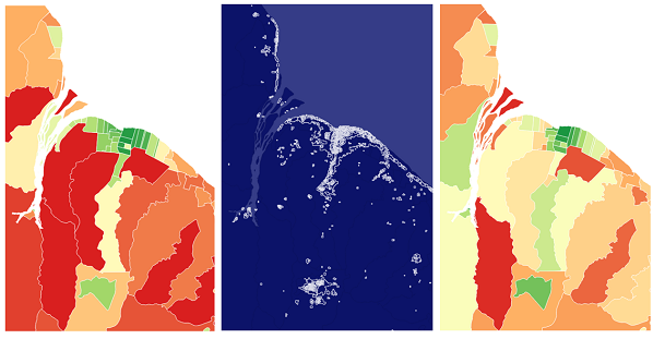
The Housing Deficit Estimator first uses a methodology based on a similar exercise by Colombia’s Department of Statistics (DANE) to numerically standardize the national quantitative and qualitative housing deficit by the smallest available administrative division.
In Guyana, as in many other countries in Latin America and the Caribbean, qualitative housing needs (low-durability materials, lack of access to services, etc) are much more pressing than quantitative needs (the availability of any kind of housing). An association analysis shows which contributors to qualitative deficit are commonly associated with one another.
Finally, using a methodology popularized by the World Bank, the Housing Deficit Estimator uses nocturnal luminosity (‘night lights’) as a proxy for urban built-up environment and infrastructure to estimate qualitative housing needs in years when census data is not available.
Inputs: Census data, nighttime satellite images
Method: Indexing, association analysis, simple regression
Language: R
Outputs: Granular estimates of qualitative housing need
6. Map and analyze the geographic reach of programs with Georeferenced Program Evaluation (GPE)
Access to resources in cities can vary greatly from neighborhood to neighborhood, often along socioeconomic lines. A successful social program must address these disparities upfront, actively seeking to provide services in areas of the city where resources are typically scarce. This R package provides geographic analysis and visualization of services used within a city, allowing the user to verify if a given program reached neighborhoods where the need is greatest, study patterns of use around the city, and otherwise assess the program’s geographic impact.
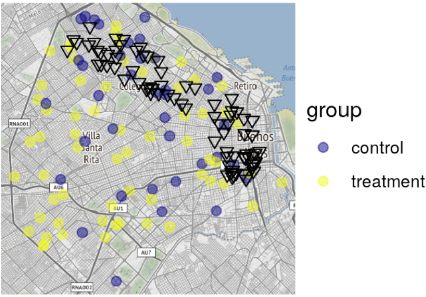
Developed to analyze the impact of Culture Pass, a program to broaden youth access to the extensive cultural life in Buenos Aires, this R package includes functions that will allow the user to:
- Georeference addresses
- Obtain base maps of any city’s urban grid
- Estimate a matrix of distances between origin and destination
- Calculate metrics of frequency, distribution by group, and distance travelled by consumers/beneficiaries to points of sale/access
- Create visualizations that explore the difference between frequency and type of consumption by consumer/beneficiary attribute
Inputs: tabular data with addresses, or “lon” and “lat” columns
Language: R
Outputs: georeferenced locations, program evaluation maps and other visualizations, estimates of distance and delay
7. UrbanPy

An open-source tool that combines spatial analysis with demographic variables. Keep learning about the tool UrbanPy here.
What’s next for the Open Urban Planning Toolbox?
Data-driven urban planning also demands proper modelling and understanding of dynamic urban systems. Upcoming HUD projects will see tools for this kind of contextual analysis added to the Toolbox, including crowd-sourced mobility mapping using General Transit Feed Specification (GTFS), a format that enables open and collaborative use of urban transport data.
Open-source software is made stronger by the community that contributes to it. We welcome users to apply the tools in their own cities, share ideas for improvement, and help identify areas of need that could be addressed with new open-source tools.
As we continue to add to our Toolbox, we will always follow key values: a shared commitment to open data and open-source tech; improved access to cutting-edge techniques, such as artificial intelligence, through active collaboration with global partners; and a focus on the participatory and democratic use of digital technology.
We’d love to hear about successful applications of these tools in the comments below. Also, please feel free to reach out for new opportunities to collaborate at [email protected].
good software
Respetados amigos,buenas tardes,
Somos un equipo de profesionales del sector de las Telecomunicaciones que queremos recibir orientación de ustedes para un emprendimiento nacional orientado al ordenamiento territorial tanto de las municipalidades como.a la ruralidad asociada a estos territorios.
Tenemos ideas, conocimiento especializado y una nueva visión del desarrollo, producto de las enseñanzas que ustedes nos prodigan.
Por favor díganos cuales eran los pasos para vincularnos a estas iniciativas.
Cordialmente
Jorge Orlando Garcia L