by Maja Schling
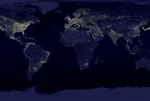
We have all marveled at these images: The Earth at night as seen from space, shrouded in hues of dark blues and greys, the distinction between continent and ocean barely perceptible in the darkness. Clearly visible, however, are the bright specks of light distributed across the world, some only dim dots surrounded by blackness, and some larger and brilliantly bright masses that stretch across the land like golden spider webs.

Photo: C. Mayhew & R. Simmon (NASA/GSFC), NOAA/ NGDC, DMSP Digital Archive.
Over the last few decades, technology has made impressive leaps that now allow us to examine our planet from a distance. The light emanating from towns and cities at night is popularly known as night-time lights (or luminosity, among experts) and can tell us a lot about human activity on the ground. A recent study by the Inter-American Development Bank (IDB) shows this can be used to assess the effectiveness of development projects.
Not only can night-time lights give an indication of the number of people living in an area, they also can reveal important insights about a region’s state of development. The greater the luminosity, the greater is the level of technological and economic advancement of the shimmering clusters below.
Since the 1970s, satellites from the United States Air Force Defense Meteorological Satellite Program, or DMSP for short, have recorded Earth-based lights around the globe on a nightly basis.
After undergoing extensive processing to remove any light sources that may disturb the measurement of human-made lights (forest fires, auroral activities, and extensive lunar light), the National Oceanic and Atmospheric Administration (NOAA) publishes the yearly average of all cloud-cover free observations in a latitude-longitude grid of rectangular pixels that each measure approximately one square kilometer.
In recent years, researchers have discovered that this strong link between luminosity and economic activity is a wonderful resource for studying the changes and differences in regional economic growth over time. That has made luminosity data a valuable tool for evaluating the impact of development projects and policies.
Data limitations often make it difficult to provide credible evidence of development effectiveness. In developing or war-torn countries, data often is simply not available. When that is the case, remotely measured night light density can offer a valid and objective measure of economic activity for surprisingly small and specific geographic units.
For example, a 2008 study used luminosity data to show that the U.S. military surge into specific neighborhoods of Baghdad in 2007 decreased levels of violence. In another study, investigators lacking regional and city-level information on economic growth were able to use luminosity data to investigate the effect of inter-city transport costs on urban economic activity in sub-Saharan Africa.
In a recent impact evaluation of an IDB-co-financed project, luminosity data was used to examine the effects of large-scale infrastructure investments in shoreline stabilization on the local economy in Small Island Developing States (SIDS).
The project, called the Coastal Infrastructure Program, was carried out in Barbados between 2002 and 2009. It focused on rehabilitating and improving coastal infrastructure near a number of select beaches in an effort to reverse the negative effects of coastal erosion.
Like many SIDS countries, the economy of Barbados relies heavily on income and employment generated by tourism, so preserving beaches is crucial to achieving sustainable economic growth.
An inherent challenge of the evaluation was how to measure the localized impact that the infrastructure works might have on economic activity near the targeted beaches. Since beneficiaries of coastal protection would include any tourists or residents visiting the beach, as well as hotels, restaurants, or other businesses located nearby, beneficiaries would be difficult to capture through individual surveys.
While Barbados has an abundance of available data at the national and parish level, it proved impossible to find beach-level disaggregated data for traditional measures of economic activity, since beaches in the country are narrow and often less than a half-kilometer long.
So how do you find a way to measure changes in economic activity around a beach within a radius of one or two kilometers?
We decided to use luminosity data to measure economic activity for each beach along the touristic West and South Coast of Barbados at annual intervals from 1992 until 2010. The analysis focused on a particular beach site, Rockley Beach, since it was the site of the most ambitious construction work in terms of both scale and investment.

Using a method called Synthetic Control, the luminosity data and other important characteristics related to individual beach sites, including beach size, location, infrastructure, and business activity were used to systematically choose comparison units among the untreated beach sites that could most closely mirror the trend in luminosity levels at Rockley Beach prior to the intervention.
In this way, impact was measured as the difference in luminosity levels after the intervention between Rockley Beach and the synthetically created control beach. This difference in luminosity trends indicated that even in just the first three years after shoreline stabilization works were completed, local economic effects were positive and indicated a strong positive trend.
The magnitude of this impact is quite substantial, as the estimated gap suggests that, over the post-treatment period of 2007-2010, luminosity per capita was increased by 9 %, which can be approximately interpreted as a rise of 9% in local GDP.
This result provides strong evidence for the development effectiveness of shoreline stabilization in an effort to not only reverse coastal erosion, but also to promote sustainable economic growth. The availability of luminosity data allowed for the first rigorous evaluation of the policy, and confirmed that the approach and subsequent large investments were justified.
The technological advances that have made the remote measurement of night light activity possible not only help illuminate development effectiveness; they are also supporting our efforts to continue improving results-based policy design.
Download here the full study “The Impact of Coastal Infrastructure Improvements on Economic Growth: Evidence from Barbados“.
About the author:
Maja Schling is a consultant in the Strategy Development Division (SPD/SDV) of the IDB. She holds a Ph.D. in Economics and specializes in the impact evaluation of development projects, with a focus on the areas of agriculture, environment, and natural resources.
For another blog post on using the synthetic control method to evaluate productive development policies visit: How to evaluate a tourism reform without a time machine?
For more information on the use of night-time lights in development studies:
Elvidge, C.D., Baugh, K.E., Kihn, E.A., Kroehl, H.W & Davis, E.R. (1997). Mapping of city lights using DMSP Operational Linescan System data. Photogrammetric Engineering and Remote Sensing, 63, 727-734.
Doll, C. N., Müller, J. P. & Morley, J. G. (2006). Mapping regional economic activity from night-time light satellite imagery. Ecological Economics, 57(1), 75-92.
Ghosh, T., Powell, R., Elvidge, C. D., Baugh, K. E., Sutton, P. C., & Anderson, S. (2010). Shedding light on the global distribution of economic activity. The Open Geography Journal, 3, 148–161.
Henderson, J. V., Storeygard, A., & Weil, D. N. (2012). Measuring economic growth from outer space. American Economic Review, 102(2), 994-1028.
Leave a Reply