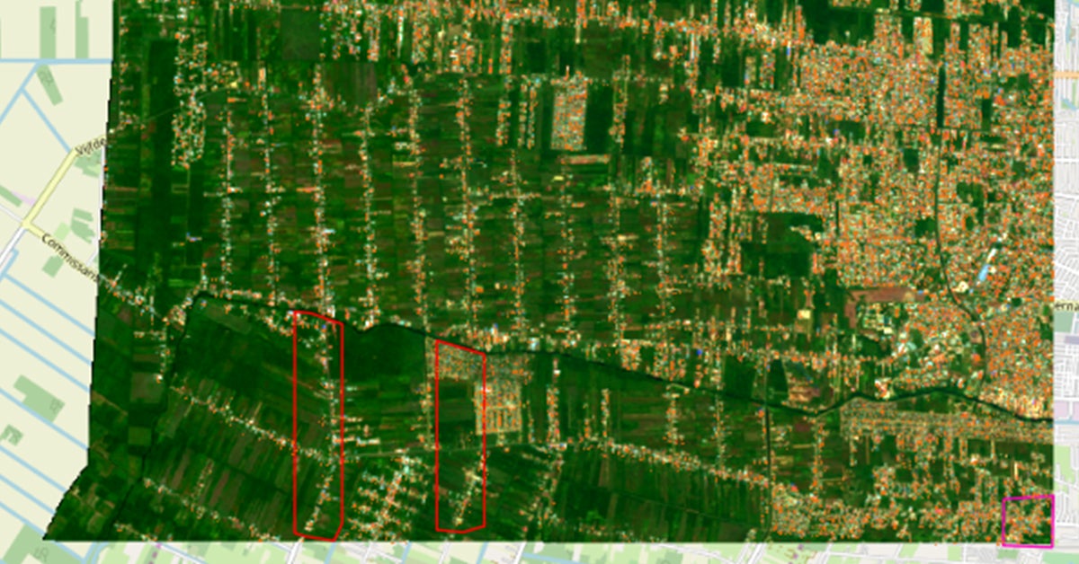
City planners often lack updated digital maps of existing buildings and structures. The Building Detection Model can automatically generate a basic map of buildings from satellite images. It uses semantic segmentation, which is the process of assigning each pixel in an image into a category; in this case, the categories are ‘building’ or ‘not building’. This allows planners to create detailed digital files of hard-to-reach and remote areas, such as the Guyana hinterland, where our partners are currently planning for housing interventions.
The general objective of this machine learning model is to support leaders in the urban development and housing sector to generate, automatically, basic maps of existing buildings in urban areas and human settlements. Beyond generating a map of existing structures, urban and housing agencies can use the model’s results to estimate population size, neighborhood density, access to resources, etc., and as a base across which to extrapolate household level information. In addition, these estimates can help with downstream tasks such as measuring and detecting unplanned/informal urban sprawl, informing planned interventions and the provision of urban ecosystem services to such areas.
The model, which uses machine learning techniques and high resolution satellite images for the basic categorization, was trained on data from Paramaribo (Suriname), Georgetown (Guyana) and Belize City (Belize), all of which have similar climate/vegetation, styles of architecture and patterns of urban sprawl. For improved results, the model should be re-trained for a new city with different topography and sprawl patterns.
This type of classification of structures is useful for urban planning tasks such as the identification and planning of informal / unplanned zones, the design and development of urban services, and to extrapolate data at the city level such as the number of buildings and population estimates. This model of real estate segmentation allows to predict raster masks and vectorized polygons of satellite images using a semantic segmentation approach. This process assigns a category to each pixel of the image. In this case, the categories used are ‘real estate’ or ‘non-real property’. By allowing a segmentation that recognizes the unique characteristics of each city (different urbanization patterns, different geographical features, etc.), this tool is applicable in several contexts.
For example, for Paramaribo, Suriname, it can take approximately eight hours to perform the manual identification of structures in a determined polygon, while the model manages to make the identification of the entire city in just one hour, using as training data labels generated through crowd-sourcing in OpenStreetMap for the area selected.
This tool is part of our Open Urban Planning Toolbox, a set of open-source tools to support each step of the urban development planning process, from early design through implementation and evaluation of projects. Open-source software is made stronger by the community that contributes to it. We welcome users to apply the tools in their own cities, share ideas for improvement, and help identify areas of need that could be addressed with new open-source tools.
Download now this open code! Building Detection: automatic classification of buildings and structures.
Olá, estou desenvolvendo uma pesquisa de mestrado em planejamento urbano e regional e gostaria de aprofundar mais sobre o uso dessas ferramentas para a realidade do Brasil e dos municípios. Vocês podem me ajudar?
Gracias por el contacto, te sugerimos escrbir a Bouskela, Mauricio Simon mbouskela@iadb.org