Inter-American Development Bank
facebook
twitter
youtube
linkedin
instagram
Abierto al públicoBeyond BordersCaribbean Development TrendsCiudades SosteniblesEnergía para el FuturoEnfoque EducaciónFactor TrabajoGente SaludableGestión fiscalGobernarteIdeas MatterIdeas que CuentanIdeaçãoImpactoIndustrias CreativasLa Maleta AbiertaMoviliblogMás Allá de las FronterasNegocios SosteniblesPrimeros PasosPuntos sobre la iSeguridad CiudadanaSostenibilidadVolvamos a la fuente¿Y si hablamos de igualdad?Home
Citizen Security and Justice Creative Industries Development Effectiveness Early Childhood Development Education Energy Envirnment. Climate Change and Safeguards Fiscal policy and management Gender and Diversity Health Labor and pensions Open Knowledge Public management Science, Technology and Innovation  Trade and Regional Integration Urban Development and Housing Water and Sanitation
  • Skip to main content
  • Skip to secondary menu
  • Skip to primary sidebar
  • Skip to footer

Ciudades Sostenibles

  • HOME
  • CATEGORIES
    • Housing
    • Sustainable development
    • Urban heritage
    • Smart cities
    • Metropolitan governance
    • Urban economics
    • Urban society
    • Cities LAB
    • Cities Network
  • Spanish

DATUM: facilitating community collection and public use of urban mobility data in the Americas

June 7, 2019 por Jordan Fischer - Edgar Lemus - Martin Quiroga - Patricio Zambrano Barragán Leave a Comment

Este artículo está también disponible en / This post is also available in: Spanish


In cities throughout Latin America and the Caribbean (LAC), public transport serves an essential role, connecting people with employment, commerce, leisure, and each other. However, public transport networks in LAC cities, both formal and informal, can lack detailed information about routes and schedules, leaving users to rely on word of mouth to know what routes can take them to their destination. Moreover, accurate and complete data is the basis for planning and decision-making processes when working towards the improvement of a city’s mobility system.

Enter community mapping, through which residents come together to gather detailed data on urban systems, ranging from informal settlements to mobility networks. Building on the growing relevance and importance of these crowdsourcing initiatives, the IDB’s Housing and Urban Development and Transport Divisions, together with partners WRI, Massachusetts Institute of Technology (MIT), Columbia University and MasterCard,are proud to launch DATUM, a regional platform that gathers past experiences, lessons learned, and open-source tools used, to serve as a central source of information on urban mobility mapping projects in LAC. Building on the initiatives already realized in the region, DATUM acts as a guide for collecting, processing, and publicizing urban mobility data. Those wishing to replicate a mapping project in their own city can visit datum.la to access a central cache of information on community mapping projects in the region. Some pioneering cities in LAC have already had great success mapping their urban mobility systems with crowdsourcing and community mapping techniques.


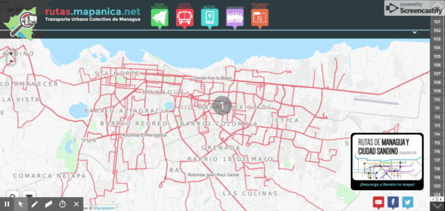
MANAGUA, Nicaragua: MapaNica

MapaNica, the Nicaraguan chapter of OpenStreetMap was founded in 2012 and provides user-friendly open data on urban mobility routes – how to get around Managua using public transport, bicycle, or on foot. The open-source website, mapanica.net, provides detailed and interactive data and maintained by the diverse community that contributes to the project.

Routes mapped on MapaNica’s interactive website.MapaNica.net, 2017 OpenStreetMap. 2012

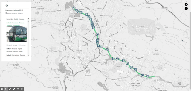
XALAPA, Mexico: MapMap

Public transport was mapped using a data collection app called MapMap, in Veracruz’s capital in 2016 and 2017. The initiative was launched with a citizen mapathon coordinated by Codeando Xalapa and the city government of Xalapa with methodological support from the World Resource Institute (WRI) and OpenStreetMap. The 162 routes successfully mapped across the city are displayed on an interactive website.

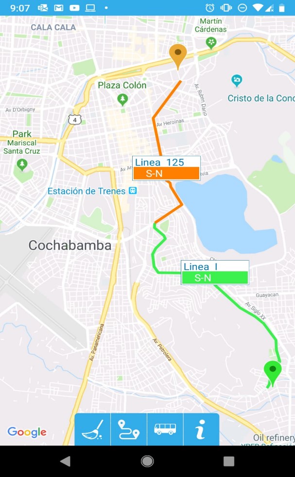
COCHABAMBA, Bolivia: Cochala

Highly decentralized systems left much guesswork to riders in Cochabamba, until a coalition of academic, coding, community-based, and international partners came together to map transport routes in the city and launch the Guía Cochala in December 2017. This free app is a lightning-fast mapping tool that helps users find their way between any two points in the city using public transport. With almost 10 thousand downloads in the first 5 months after its launch, Guía Cochala promises to revolutionize the public transport experience in Cochabamba. The project’s success reached international heights when the program coordinators were contacted to incorporate the mobility data that they had collected into global databases like OpenStreetMap.

The Guia Cochala app shows an optimized path between any two points selected by the user. Guía Cochala, 2018.

SANTIAGO DE LOS CABALLEROS, Dominican Republic: Mapeando Santiago

To mark the launch of DATUM, the IDB and its partners have started a community mapping pilot in Santiago de los Caballeros, Dominican Republic. Santiago does not currently have comprehensive, standardized information on transport routes open to the public. This affects residents’ ability to move around their city, limiting access to employment opportunities, especially among residents with fewer resources.

Mapeando Santiago, as the initiative is called, seeks to address this by mapping over 60 routes in the greater Santiago area, including intercity routes, using open data and open-source code. The pilot is being carried out in collaboration with the city’s Municipal authorities, CDES, and the Pontificia Universidad Católica Madre y Maestra (PUCMM), as well as with transport operators, users, and civil society stakeholders.

Between June 10th and June 28th, students from PUCMM will travel the city collecting standardized data using the same MapMap app used in Xalapa. Students will be assigned a route, travel along it using the MapMap app on their phones to record the movement in GTFS data, verify the route, and add it to the central dataset. Once the data quality is verified, routes will be additionally consulted with civil society to gather additional information such as safety and inclusion.

The results of Mapeando Santiago will be shared with city planners and transport authorities to improve services and related policies, shared with mapping service providers such as Google Maps and Moovit to incorporate into their datasets, and made available to the general public through the DATUM platform. The results of Mapeando Santiago will be presented in August 2019, and the data will be made available in the upcoming IDB-sponsored hackathon to be held in the Dominican Republic in the fall of 2019. This will reinforce local capacity with GTFS and geospatial analysis fostered during the initial project.

Open data and open-source software keep projects transparent and accountable to residents and improve access to the data. A standardized GTFS format ensures that data will be compatible with apps and software used in the transit field. Open-source software has the added benefit of increasing the sustainability of a project, as an interruption in funding will not affect the use of the software.

Sustainability can also be promoted by the involvement of local groups. Already established local communities – such as OpenStreetMap, coding communities, and civil society – can be tapped to ensure that the project best serves residents’ needs, in turn ensuring the continued use of the project. Many projects in the region have found that academic partners can improve sustainability by providing well-trained students to collect and process data.

Mapeando Santiago is just the first of what we hope will be many community mapping projects carried out with the support of DATUM. Are you interested in community mapping projects in your city? Learn more about partners’ experiences, suggested methodology, and open-source code for mapping and processing data at datum.la.


View this post on Instagram


A post shared by BID Ciudades Sostenibles (@bid_ciudades) on Jun 6, 2019 at 10:11am PDT


Filed Under: Emerging cities, Smart cities Tagged With: datos abiertos, Datum, mobilidad, mobilidad urbana, transporte urbano

Jordan Fischer

Jordan Jasuta Fischer trabaja en inteligencia artificial y análisis cognitivo en la división de sector público de IBM. Previamente, se especializaba en proyectos de código abierto, tecnología cívica y análisis geoespacial en Latinoamérica con el BID. Su experiencia en soluciones tecnológicas, gerencia de datos, y análisis avanzado en el campo del desarrollo internacional ha cubierto temas tan diversos como la administración pública, la salud pública, y los derechos humanos. Jordan tiene una maestría en Análisis de Negocios de la Universidad de George Washington y un bachillerato en Economía de la Universidad de Utah.

Edgar Lemus

Edgar is a map-maker and civic technologist with a background in Environmental Science, Policy and Management. At the IDB, he explores strategies in public service innovation in Latin America and the Caribbean. Particularly, through the deployment of open software for geostatistical analysis to improve the technical capacities of local governments, bridge the geographic data gap in the region, and build climate change resiliency.

Martin Quiroga

Since 2015, Martín Quiroga Barrera Oro has contributed to IDB's projects on housing, local economic development, environmental restoration, urban revitalization and mobility. Prior to joining the IDB, he worked on monitoring and evaluation of projects at the Organization of American States (OAS) and for a World Bank-sponsored program aimed at improving public health systems through results-based financing. He is the co-author of “Territorial Agreements in the Construction of Border Regions: for a Greater Integration at Multiple Levels”, among other publications on regional funds, local governments and governance. Martin has delivered courses on research methodology and economic policy. He received a master’s degree in Public Policy with a focus on Economic Policy. Martin has been the recipient of scholarships given by institutions such as Fulbright, Brown University and Johns Hopkins to attend seminars on population studies, epidemiology and development.

Patricio Zambrano Barragán

Patricio Zambrano-Barragán was a Housing and Urban Development Specialist at the Inter-American Development Bank. He currently led urban development projects throughout Latin America and the Caribbean, including housing policy and finance projects; resilient urban infrastructure; and geospatial and civic data analytics. Prior to joining the IDB, he led research on territorial management and climate-ready infrastructure at the Massachusetts Institute of Technology and the Natural Resources Defense Council (NRDC). Patricio has worked with the Office of the Deputy Mayor in Quito, Ecuador; with the New York City Department of Housing Preservation and Development (HPD) on distressed asset financing; and as a management consultant with New York-based Katzenbach Partners. Patricio is a doctoral candidate in City and Regional Planning at the University of Pennsylvania, and holds a Master's in City and Regional Planning from the Massachusetts Institute of Technology and a B.A. in Political Science from Yale University.

Reader Interactions

Leave a Reply Cancel reply

Your email address will not be published. Required fields are marked *

Primary Sidebar

Follow Us

Subscribe

Description

Este es el blog de la División de Vivienda y Desarrollo Urbano (HUD) del Banco Interamericano de Desarrollo. Súmate a la conversación sobre cómo mejorar la sostenibilidad y calidad de vida en ciudades de América Latina y el Caribe.

Search

Recent Posts

  • Cities on the Brink: How to Protect Latin America from Extreme Heat and Wildfires
  • São Luís: Pioneering Interventions Transform The Historic Center Into An Inclusive And Accessible Space
  • Strengthening Cooperation for Climate-Resilient Urban Futures
  • Unlocking the Power of Blue Carbon in Urban Areas: Protecting Mangroves and Financing Their Conservation
  • Urban empowerment in action: women from vulnerable communities earn certification in civil construction

¡Síguenos en nuestras redes!

Footer

Banco Interamericano de Desarrollo
facebook
twitter
youtube
youtube
youtube

    Blog posts written by Bank employees:

    Copyright © Inter-American Development Bank ("IDB"). This work is licensed under a Creative Commons IGO 3.0 Attribution-NonCommercial-NoDerivatives. (CC-IGO 3.0 BY-NC-ND) license and may be reproduced with attribution to the IDB and for any non-commercial purpose. No derivative work is allowed. Any dispute related to the use of the works of the IDB that cannot be settled amicably shall be submitted to arbitration pursuant to the UNCITRAL rules. The use of the IDB's name for any purpose other than for attribution, and the use of IDB's logo shall be subject to a separate written license agreement between the IDB and the user and is not authorized as part of this CC- IGO license. Note that link provided above includes additional terms and conditions of the license.


    For blogs written by external parties:

    For questions concerning copyright for authors that are not IADB employees please complete the contact form for this blog.

    The opinions expressed in this blog are those of the authors and do not necessarily reflect the views of the IDB, its Board of Directors, or the countries they represent.

    Attribution: in addition to giving attribution to the respective author and copyright owner, as appropriate, we would appreciate if you could include a link that remits back the IDB Blogs website.


    Privacy Policy

    Derechos de autor © 2025 · Magazine Pro en Genesis Framework · WordPress · Log in

    Banco Interamericano de Desarrollo

    Aviso Legal

    Las opiniones expresadas en estos blogs son las de los autores y no necesariamente reflejan las opiniones del Banco Interamericano de Desarrollo, sus directivas, la Asamblea de Gobernadores o sus países miembros.

    facebook
    twitter
    youtube
    This site uses cookies to optimize functionality and give you the best possible experience. If you continue to navigate this website beyond this page, cookies will be placed on your browser.
    To learn more about cookies, click here
    X
    Manage consent

    Privacy Overview

    This website uses cookies to improve your experience while you navigate through the website. Out of these, the cookies that are categorized as necessary are stored on your browser as they are essential for the working of basic functionalities of the website. We also use third-party cookies that help us analyze and understand how you use this website. These cookies will be stored in your browser only with your consent. You also have the option to opt-out of these cookies. But opting out of some of these cookies may affect your browsing experience.
    Necessary
    Always Enabled
    Necessary cookies are absolutely essential for the website to function properly. This category only includes cookies that ensures basic functionalities and security features of the website. These cookies do not store any personal information.
    Non-necessary
    Any cookies that may not be particularly necessary for the website to function and is used specifically to collect user personal data via analytics, ads, other embedded contents are termed as non-necessary cookies. It is mandatory to procure user consent prior to running these cookies on your website.
    SAVE & ACCEPT