Este artículo está también disponible en / This post is also available in: Spanish
The proximity of urban centers to the coast makes our Caribbean cities vulnerable to rising sea levels and the increasingly devastating effects of storms. In the Dominican Republic, 25% of the built-up area between 1995 and 2015 is located within three kilometers of the coast, making these areas highly exposed to climate events such as hurricanes and floods. This affects not only local economies, which largely depend on tourism, but also the lives of residents themselves.
While the need to adapt our cities to climate impacts is evident, how to achieve this seems an open question. In this article, we provide some concrete answers based on the climate adaptation plan for the Colonial City of Santo Domingo, a valuable reference for other cities in Latin America and the Caribbean (LAC).
Comprehensive Program for the Touristic and Urban Development of the Colonial City
Through the “Comprehensive Program for the Touristic and Urban Development of the Colonial City” (PIDTUCCSD), led by the Ministry of Tourism (MITUR) in coordination with the Ministry of Culture and the National District Municipality, the country is committed to revitalizing the Colonial City, focusing on urban, economic, and touristic improvement. This effort includes the restoration of public spaces and historic monuments, improving the quality of life for its inhabitants, boosting the local economy, and strengthening governance in this urban area.
This initiative has placed special emphasis on ensuring that all urban rehabilitation actions are prepared to face the impacts of climate change. Among the natural phenomena exacerbated by this, tropical storms are particularly worrisome, as they can cause three types of flooding: riverine, pluvial, and coastal. Therefore, the main purpose of the Adaptation Plan is to provide adaptation strategies to minimize the risk of flooding increased by climate change in the Colonial City of Santo Domingo.
How to Define Climate Resilience Strategy and Measures?
In order to analyze the risk and guide adaptation interventions, the Climate Change Resilience Integration into Urban Renewal Projects (CCSD) project in vital areas and emblematic public spaces such as Parque Colón and Calle El Conde, was articulated in three essential phases:
1. Field Information Gathering: This phase included the collection of detailed topography data for CCSD and bathymetry for the Ozama River, which allowed establishing a solid base for analysis.
2. Hydrological Modeling: A modeling of the effects of climate change on the hydrological regime was carried out from 2015 to 2100, with long-term projections of changes in precipitation and runoff patterns.
3. Hydrodynamic Modeling of Flood Threats: This stage evaluated the risk of flooding from extreme rainfall and overflow of the Ozama River under historical and projected climate change scenarios.
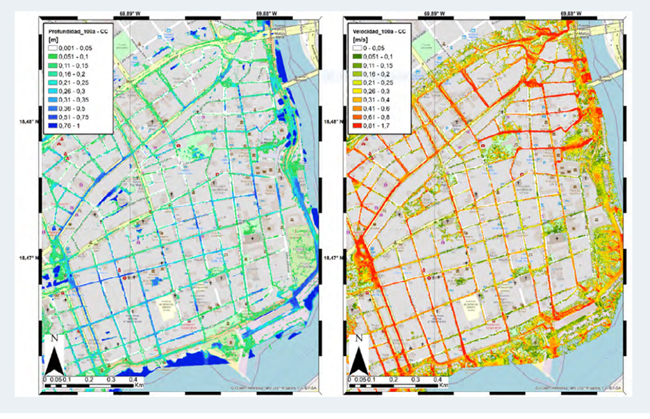
The resulting flood threat maps, detailing flood depths and velocities throughout the CCSD, were fundamental for the development of adaptation strategies. A participatory workshop with stakeholders, including MITUR, the National District Municipality (NDM), Monumental Heritage, and public space designers, allowed defining specific recommendations for Calle El Conde and Parque Colón.
Thus, the plan prioritizes the threat of pluvial floods and has conducted a detailed analysis of risk areas, identifying critical areas such as San Lázaro, Puerta de la Misericordia, El Carmen, Regina, and Santa Bárbara, where pedestrian safety could be at risk.
Image 1: On the left, the map of pluvial flood threat – flood depth [m]. On the right, the map of pluvial flood threat – average flow velocity [m/s] – Climate change scenario – 100-year return period event.
Adopted Measures:
In the case of Calle El Conde, sustainable stormwater drainage solutions were implemented, such as:
- Cisterns and rainwater retention: strategies to capture and temporarily store rainwater, reducing the impact of extreme precipitation.
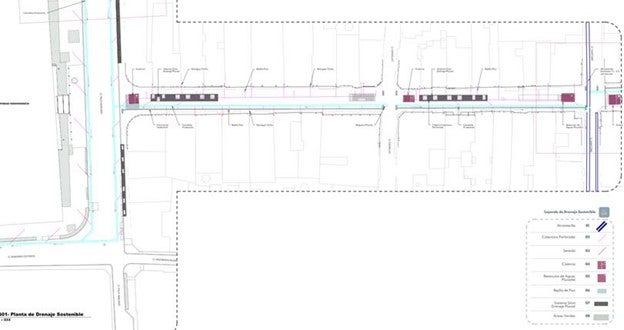
- Silva System of stormwater drainage and permeable pavements: these solutions allow water infiltration into the soil, decreasing runoff and improving rainwater management. They were applied in important intersections, such as Palo Hincado, Espaillat, Santomé, Sánchez, José Reyes, 19 de Marzo, and Duarte, with permeable pavements indicated in the gray areas of the plans.
The image below (image 2), showing the stretch between the intersection with Palo Hincado Street and Santomé Street, illustrates the proposed permeable pavements at the beginning of Calle El Conde to manage excess precipitation. Additionally, the rainwater retention systems implemented at each intersection are highlighted in magenta, demonstrating a comprehensive and multifaceted approach to climate resilience in the Colonial City of Santo Domingo.
Image 2: Intersection Palo Hincado Street and Santomé Street
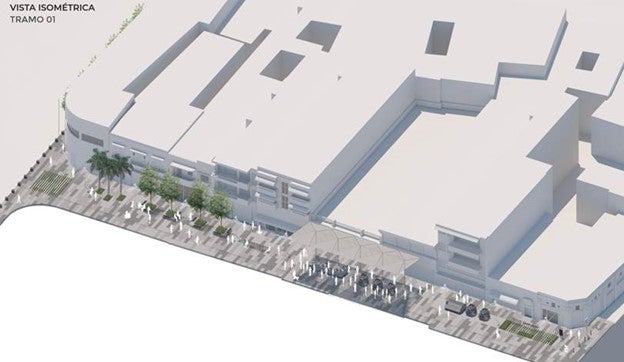
The isometric representation of “Segment 01” (image 3) offers a detailed and three-dimensional perspective of the proposed interventions to improve water management on Calle El Conde, particularly focused on flood mitigation. In this view, it is possible to appreciate how permeable pavement systems and rainwater retention systems are integrated into urban design, enhancing both functionality and aesthetics of the space.
This integration of nature-based solutions demonstrates the possible combination of effective flood risk reduction measures with the enrichment of the urban environment and the historical and cultural heritage of the Colonial City of Santo Domingo.
Image 3: Isometric view of Segment 01
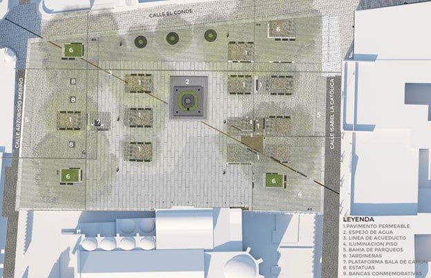
At the heart of the Colonial City, Parque Colón adopts innovative climate change adaptation measures to improve its capacity to manage rainwater and increase its resilience to floods. These measures include the implementation of floor grilles and the strategic use of permeable pavement in specific areas. All this was designed to harmoniously adapt to the historical and aesthetic value of the park, ensuring that this public space continues to be a meeting and recreation place for the community.
Image 4: Parque Colón
Acting now, thinking for the future: perspectives on climate adaptation in the Colonial City of Santo Domingo
The implementation of Sustainable Urban Drainage Systems (SUDS) as part of its Climate Change Adaptation Plan in the Colonial City of Santo Domingo marks a significant milestone in environmental and urban management. The inclusion of cisterns to store runoff water, permeable pavement in Parque Colón, and floodable tree pits on Calle El Conde, represents an innovative and sustainable approach to tackling the challenges posed by climate change.
These measures, far from replacing existing urban infrastructure, are designed to complement it, improving the city’s capacity to manage excess rainwater. By working together, these systems not only reduce the risk of floods but also promote the reuse and sustainable management of runoff water. The integration of these sustainable solutions into the design and sizing of the proposed structures reflects a holistic and evidence-based approach to climate adaptation.
Flood Adaptation Plan for Santo Domingo City, an inspiring example for other municipalities
This proactive approach underscores the commitment of the Dominican Government and the IDB to protecting and enhancing the resilience of the Colonial City in the face of climate change challenges. It ensures a safer and more sustainable future for its residents and visitors, and sets a reference model for other municipal plans developed under the new Land Use and Human Settlements Territorial Planning Law (LOTUSAH).
The Flood Adaptation Plan for the Colonial City of Santo Domingo not only protects a site of invaluable historical and cultural value but also leads the way towards a more resilient and sustainable urban planning in the Dominican Republic. In doing so, it becomes an inspiring example for other cities in the Caribbean and beyond, demonstrating that it is possible to harmonize heritage preservation with the needs of climate adaptation.

Leave a Reply