Inter-American Development Bank
facebook
twitter
youtube
linkedin
instagram
Abierto al públicoBeyond BordersCaribbean Development TrendsCiudades SosteniblesEnergía para el FuturoEnfoque EducaciónFactor TrabajoGente SaludableGestión fiscalGobernarteIdeas MatterIdeas que CuentanIdeaçãoImpactoIndustrias CreativasLa Maleta AbiertaMoviliblogMás Allá de las FronterasNegocios SosteniblesPrimeros PasosPuntos sobre la iSeguridad CiudadanaSostenibilidadVolvamos a la fuente¿Y si hablamos de igualdad?Home
Citizen Security and Justice Creative Industries Development Effectiveness Early Childhood Development Education Energy Envirnment. Climate Change and Safeguards Fiscal policy and management Gender and Diversity Health Labor and pensions Open Knowledge Public management Science, Technology and Innovation  Trade and Regional Integration Urban Development and Housing Water and Sanitation
  • Skip to main content
  • Skip to secondary menu
  • Skip to primary sidebar
  • Skip to footer

Ciudades Sostenibles

  • HOME
  • CATEGORIES
    • Housing
    • Sustainable development
    • Urban heritage
    • Smart cities
    • Metropolitan governance
    • Urban economics
    • Urban society
    • Cities LAB
    • Cities Network
OpenStreetMap Extraction tool

OpenStreetMap Extraction tool: generating neighborhood-level maps

July 12, 2019 por Patricio Zambrano Barragán - Jordan Fischer - Edgar Lemus 2 Comments


Considering the digital revolution, Latin American and Caribbean cities should be poised to generate, analyze, and disseminate urban data. Yet, all too often, our partners do not have the tools necessary for delivering urban services to informal areas, identifying and allocating lands best suited for development while protecting at-risk areas, and working with individual families to assess and improve housing conditions, among other tasks. Much of the existing technology available to support this work is either too expensive, difficult to use, or not designed for the specific conditions of cities in a developing country.

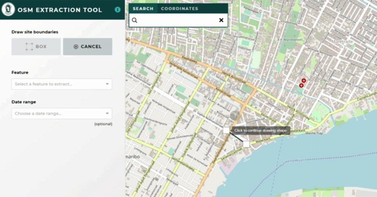
Even in relatively well-established urban areas, development can take place informally or without complete records. Luckily, we have developed a simple interface to extract data. The OpenStreetMap Data Extraction Tool harnesses the power of open data to close information gaps and increase planning accuracy immediately and free of charge. This tool uses a simple interface that allows extracting detailed data from the Open Street Map platform, a collaborative project to create editable and free maps.

OpenStreetMap (OSM) uses crowdsourcing to generate detailed data at the building level. It is not always easy to download this data, however. Previously, an API called Overpass has been used to pull this data, but it requires knowledge of its own specific query language, which can be a significant barrier to urban planners without training in programming.

Our OSM Extraction Tool eliminates the need to write any code and offers a more user-friendly and intuitive interface to extract relevant shapefiles and fill data gaps. The tool allows users to select specific areas; download detailed maps of roads, buildings, and other features in those areas; and update or add information to existing GIS data. Files downloaded from the OSM Extraction Tool can be conflated (selectively merged) with existing records using JOSM (Java OpenStreetMap) editor.

In addition to the open source, the web application provides a user-friendly interface to facilitate access to OSM data, built on the basis of the Overpass API. OSM tags are grouped into more general features in the config file. The configuration can be based on values of the labels, keys of the labels, or several labels at the same time. The specified OSM tags are converted into Overpass API queries and collected from that service.

This tool is part of our Open Urban Planning Toolbox, a set of open-source tools to support each step of the urban development planning process, from early design through implementation and evaluation of projects. Open-source software is made stronger by the community that contributes to it. We welcome users to apply the tools in their own cities, share ideas for improvement, and help identify areas of need that could be addressed with new open-source tools.

Download now this open code! OSM Extraction Tool: Simple interface to extract data from Openstreetmap.


Filed Under: Smart cities

Patricio Zambrano Barragán

Patricio Zambrano-Barragán was a Housing and Urban Development Specialist at the Inter-American Development Bank. He currently led urban development projects throughout Latin America and the Caribbean, including housing policy and finance projects; resilient urban infrastructure; and geospatial and civic data analytics. Prior to joining the IDB, he led research on territorial management and climate-ready infrastructure at the Massachusetts Institute of Technology and the Natural Resources Defense Council (NRDC). Patricio has worked with the Office of the Deputy Mayor in Quito, Ecuador; with the New York City Department of Housing Preservation and Development (HPD) on distressed asset financing; and as a management consultant with New York-based Katzenbach Partners. Patricio is a doctoral candidate in City and Regional Planning at the University of Pennsylvania, and holds a Master's in City and Regional Planning from the Massachusetts Institute of Technology and a B.A. in Political Science from Yale University.

Jordan Fischer

Jordan Jasuta Fischer trabaja en inteligencia artificial y análisis cognitivo en la división de sector público de IBM. Previamente, se especializaba en proyectos de código abierto, tecnología cívica y análisis geoespacial en Latinoamérica con el BID. Su experiencia en soluciones tecnológicas, gerencia de datos, y análisis avanzado en el campo del desarrollo internacional ha cubierto temas tan diversos como la administración pública, la salud pública, y los derechos humanos. Jordan tiene una maestría en Análisis de Negocios de la Universidad de George Washington y un bachillerato en Economía de la Universidad de Utah.

Edgar Lemus

Edgar is a map-maker and civic technologist with a background in Environmental Science, Policy and Management. At the IDB, he explores strategies in public service innovation in Latin America and the Caribbean. Particularly, through the deployment of open software for geostatistical analysis to improve the technical capacities of local governments, bridge the geographic data gap in the region, and build climate change resiliency.

Reader Interactions

Comments

  1. Chris Hills says

    October 8, 2019 at 5:49 pm

    This is a great tool! Please consider adding support for exporting data in the open OGC Geopackage format in addition to the proprietary ESRI Shapefile format.

    Reply
  2. Gustavo Alomia says

    October 17, 2019 at 6:21 am

    Its an usefull tool, i want to know if is possible once the shapefiles are donwloaded, create automatically by code multyple new shapefiles on an specific area?

    Reply

Leave a Reply Cancel reply

Your email address will not be published. Required fields are marked *

Primary Sidebar

Follow Us

Subscribe

Description

Este es el blog de la División de Vivienda y Desarrollo Urbano (HUD) del Banco Interamericano de Desarrollo. Súmate a la conversación sobre cómo mejorar la sostenibilidad y calidad de vida en ciudades de América Latina y el Caribe.

Search

Recent Posts

  • Cities on the Brink: How to Protect Latin America from Extreme Heat and Wildfires
  • São Luís: Pioneering Interventions Transform The Historic Center Into An Inclusive And Accessible Space
  • Strengthening Cooperation for Climate-Resilient Urban Futures
  • Unlocking the Power of Blue Carbon in Urban Areas: Protecting Mangroves and Financing Their Conservation
  • Urban empowerment in action: women from vulnerable communities earn certification in civil construction

¡Síguenos en nuestras redes!

Footer

Banco Interamericano de Desarrollo
facebook
twitter
youtube
youtube
youtube

    Blog posts written by Bank employees:

    Copyright © Inter-American Development Bank ("IDB"). This work is licensed under a Creative Commons IGO 3.0 Attribution-NonCommercial-NoDerivatives. (CC-IGO 3.0 BY-NC-ND) license and may be reproduced with attribution to the IDB and for any non-commercial purpose. No derivative work is allowed. Any dispute related to the use of the works of the IDB that cannot be settled amicably shall be submitted to arbitration pursuant to the UNCITRAL rules. The use of the IDB's name for any purpose other than for attribution, and the use of IDB's logo shall be subject to a separate written license agreement between the IDB and the user and is not authorized as part of this CC- IGO license. Note that link provided above includes additional terms and conditions of the license.


    For blogs written by external parties:

    For questions concerning copyright for authors that are not IADB employees please complete the contact form for this blog.

    The opinions expressed in this blog are those of the authors and do not necessarily reflect the views of the IDB, its Board of Directors, or the countries they represent.

    Attribution: in addition to giving attribution to the respective author and copyright owner, as appropriate, we would appreciate if you could include a link that remits back the IDB Blogs website.


    Privacy Policy

    Derechos de autor © 2025 · Magazine Pro en Genesis Framework · WordPress · Log in

    Banco Interamericano de Desarrollo

    Aviso Legal

    Las opiniones expresadas en estos blogs son las de los autores y no necesariamente reflejan las opiniones del Banco Interamericano de Desarrollo, sus directivas, la Asamblea de Gobernadores o sus países miembros.

    facebook
    twitter
    youtube
    This site uses cookies to optimize functionality and give you the best possible experience. If you continue to navigate this website beyond this page, cookies will be placed on your browser.
    To learn more about cookies, click here
    X
    Manage consent

    Privacy Overview

    This website uses cookies to improve your experience while you navigate through the website. Out of these, the cookies that are categorized as necessary are stored on your browser as they are essential for the working of basic functionalities of the website. We also use third-party cookies that help us analyze and understand how you use this website. These cookies will be stored in your browser only with your consent. You also have the option to opt-out of these cookies. But opting out of some of these cookies may affect your browsing experience.
    Necessary
    Always Enabled
    Necessary cookies are absolutely essential for the website to function properly. This category only includes cookies that ensures basic functionalities and security features of the website. These cookies do not store any personal information.
    Non-necessary
    Any cookies that may not be particularly necessary for the website to function and is used specifically to collect user personal data via analytics, ads, other embedded contents are termed as non-necessary cookies. It is mandatory to procure user consent prior to running these cookies on your website.
    SAVE & ACCEPT