Este artículo está también disponible en / This post is also available in: Spanish
Walking is one of the most recommended physical activities by doctors, especially for those who do not engage in much exercise. However, doing so in the summer on the streets of cities, especially in their central areas, can be a dangerous task for certain groups. Who hasn’t suddenly felt the effects of a heatstroke?
The heat in cities is not only present in their central areas, but it is true that in some neighborhoods and locations, it becomes more oppressive than in others. This sensation of burning on the skin and hot asphalt underfoot is a sign of the phenomenon known as “urban heat islands.”
In this article, we invite you to learn how the IDB, through its Housing and Urban Development Division, is making it possible for municipalities in Latin America and the Caribbean (LAC) to detect heat islands using a new intelligent software called URSA (access an article about this tool here). Don’t miss this blog post, which could be the first step in addressing the mitigation of high-temperature effects caused by climate change in your city.
How are urban heat islands formed?
The reasons for the creation of urban heat islands are multiple and well-known. Here are some of the most common causes:
- The scarcity of vegetation and green areas that hinders temperature reduction through the evaporation of water from plants and the shade protection of trees.
- The presence of large buildings that absorb heat and block the flow of air, preventing the city from cooling down through wind.
- The density of dark surfaces and high thermal inertia, such as asphalt streets, which absorb more solar radiation.
- Atmospheric pollution from “greenhouse gases,” trapping solar radiation and increasing air temperature by preventing heat dissipation.
- Industrial activities and excessive use of air conditioning systems that add thermal energy to their immediate environment.
One or several of these situations are common in any part of our cities. Therefore, urban areas always experience higher temperatures than surrounding areas. Some studies indicate that temperature differences of up to 15°C have been measured between rural and urban areas. Urban heat islands exacerbate this problem, concentrating in certain areas of a city and disproportionately affecting those who reside there.
What effects do heat islands have on health?
Urban heat islands turn into real ovens on hot days and during heatwaves. These harmful microclimates have severe consequences for the health of residents, contributing to diseases (and even higher mortality) caused by general discomfort, respiratory difficulties, and heat strokes.
According to a recent study, the combination of humidity near 100% and a global temperature increase of less than 3°C is a deadly threat to health. The same study indicates that prolonged exposure to temperatures above 35°C and high relative humidity significantly reduces the body’s cooling capacity.
This phenomenon is common in our region. According to the latest IPCC assessment report, the frequency, intensity, and duration of heatwaves will increase in LAC, projecting events lasting more than 60 days by the end of the century. It is also known that extreme heat affects low-income populations more. So much so that the United Nations Office for the Coordination of Humanitarian Affairs (OCHA) has published a report highlighting how extreme heat impacts this segment of the population, suggesting, as one of the first steps, the diagnosis and strengthening of forecasts to anticipate and reduce its impacts on vulnerable and exposed populations.
Urban heat islands also increase energy consumption, invested in cooling, and affect the economy by reducing commercial activity due to less street circulation, as well as the cessation of outdoor work typical of the construction or agricultural sector.
How can we prevent heat islands? By addressing the causes, for example, by creating new green spaces, increasing green roofs and facades, calming traffic, or better planning to avoid the construction of large uninterrupted building masses. And, as a helpful tool, we have technology to precisely identify the most affected areas.
URSA, a tool to guide urban planning with satellite data
In a previous article, we introduced URSA (Urban Reporting based on Satellite Analysis), a digital system to support urban planning developed by the IDB City Lab and the Center for the Future of Cities at Tecnológico de Monterrey. The application provides simplified access to the vast amount of information captured by satellite sensors, collecting, processing, and presenting key information for the territorial diagnosis of cities.
Among other functions, URSA offers a viewer of urban heat islands, currently available for any city in LAC with a population greater than 100,000 inhabitants.

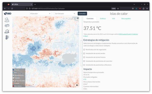
To show an example, we selected the metropolitan area of San Salvador, El Salvador. By clicking on “Query” and then on the “Heat Islands” icon, the data captured by the Landsat 8 satellite, whose sensors estimate ground temperature, is downloaded. Upon completion of the download, a map is presented that identifies heat islands, interpreted as areas where the ground temperature shows a higher increase compared to the surrounding rural area.
The map is interactive and allows for detailed analysis of the region by zooming in on specific districts. Additionally, URSA goes beyond measuring heat and, in the attached control panel, offers the possibility to explore the effect of implementing heat island mitigation strategies, such as adding tree mass or applying reflective material to pavement, allowing the calculation of temperature reduction that could be achieved with each type of intervention.

There is also a section that generates summary graphs, and another that details the estimation methodology used.
Can the data be downloaded? For a specialized audience, such as an urban planning team, it is logical to want access to a download of data compatible with geospatial analysis applications, such as QGIS or ArcGIS. URSA makes this possible, allowing the integration of these data as an additional geographic layer along with other frequently used layers in the municipality. In response to this need, there is a “Downloads” section that allows the export of data in a standard format that can be used with other tools.
In the example presented in the images, the estimated ground temperatures have been exported and opened with QGIS (another open-source software product) to analyze the information in the context of the location of health centers in that metropolitan area.

Access URSA and monitor heat islands in your city!
To facilitate the planning and management of cities and metropolitan areas, the IDB has made URSA available to cities as an open-source tool with no access restrictions. You can download it from the IDB’s open-source repository, where you will also find documentation that provides detailed instructions on how to install and use it.
We hope this is the first step in making our cities a healthier and more pleasant place to live. Feel free to share your experience using this application in the comments section. We would love to hear from you.


Leave a Reply